Submitted by Steve Turner on
The UK Surface and Groundwater Archives Committee convened for its 35th annual meeting at CEH’s Wallingford Headquarters on Wednesday 7th March.
The Committee comprises representatives of organisations from across the UK involved in the measurement, management or use of hydrometric data. This year’s meeting was attended by the Scottish Environment Protection Agency, Environment Agency, Natural Resources Wales, Department for Infrastructure - Rivers (NI), NERC, the British Hydrological Society, Met Office, Canal and Rivers Trust, British Geological Survey, DEFRA, CIWEM and representatives from the UK water industry. Amongst the items discussed at this year’s meeting was a review of the activities of the NRFA over the last 12 months.
As normal the NRFA’s activities have included updating and ongoing maintenance of the nation’s central database for hydrometric data. Ensuring that the archive is up-to-date involves an intensive programme of year round work to quality control new data before it is added to the archive and make corrections and updates to existing data. The NRFA’s core daily mean flow dataset alone was subject to around 750,000 updates and changes in the last 12 months.
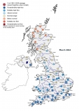
The annual update to the archive this year contained data for water year 2015/2016, an extreme year in hydrological terms, as highlighted in the NHMP report and Weather paper published in 2016. There were numerous new river flow records broken during 2015/2016 – 107 daily flow records and 70 peak flow records.
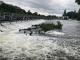
Other activities over the last year include a four day liaison visit in October, visiting gauging stations in the Greater Manchester, Merseyside & Cheshire and Cumbria & Lancashire areas of the Environment Agency. Such visits allow the NRFA’s Regional Representatives to update their knowledge of current equipment, processes and problems at each site, giving them a better understanding of how the data are measured. This information informs the quality control of data submitted to the archive and allows metadata updates to inform the user community of new and emerging issues which should be considered when analysing NRFA data. Another visit is planned to the EA’s East Anglia area later in March 2018.
NRFA staff continue to liaise and engage with key stakeholders and the user community. In November 2017, the NRFA hosted Environment Agency Hydrology staff for a workshop on Data Quality. At the end of March, NRFA staff will also attend the Flood & Coast 2018 exhibition in Telford, which will provide further opportunities for community engagement.
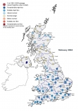
2017/2018 saw two releases of the WINFAP-FEH data files for use in flood estimation – the most recent being version 6 in February 2018. In addition to the core peak flow data, a swathe of metadata updates have been included, which relate to FEH catchment descriptors and suitabilities, ratings and datums, missing and rejected data and station descriptions. This additional information about the gauging stations is provided to allow hydrologists to make informed judgements regarding use of the data.
The NRFA website remains very popular and has seen further increases in activity. Over 2017, there were over 44,500 downloads of river flow, spatial and metadata and a total of 755,090 page views by 65,875 users across all pages on the NRFA website.
The National Hydrological Monitoring Programme (NHMP), operated jointly by the Centre for Ecology & Hydrology and British Geological Survey has continued to publish the monthly Hydrological Summaries for the UK and published three blog posts on the developing hydrological situation in April 2017, August 2017 and December 2017.
Looking forward into 2018/2019 the NRFA hope to launch a number of new developments designed to further improve access to our data and help users to better understand the UK freshwater environment.