Submitted by Steve Turner on
The National River Flow Archive has released an update to its Peak Flow Dataset including the files for use in the WINFAP software for flood estimation.
The dataset includes Annual Maxima (AMAX) and Peaks over Threshold (POT) data for 935 gauging stations which have been updated with an additional water year of data (October 2018 to September 2019) in England, Northern Ireland, Wales and for those stations previously included in the period-of-record Review in Scotland (released in Version 6 to 8).
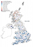
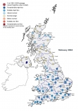
Provisional data has also been included for water year 2019/2020 for 87 stations in those areas that experienced exceptional flooding events in November 2019 and February 2020. The areas include: Wales, Northern Ireland and in some parts of England (North East, Yorkshire, East Midlands, West Midlands (West), Greater Manchester, Merseyside & Cheshire and Cumbria & Lancashire).
As well as the additional water year of data, a period-of-record review was undertaken at 20% of stations across England, Scotland and Wales – around 6,000 years of data!
The period-of-record review element provides an extensive check of the full record of data for 143 stations in the Peak Flow Dataset. It covers:
- Flow and stage data (including the extension of the dataset with recent and where applicable, early records)
- Gaugings and ratings
- Missing data periods
- FEH Suitability
- Metadata (station descriptions, station type, datum history, POT threshold, bankfull stage)
- Unrepresentative data periods
- Rejected data
A list of stations that were included in this year’s period-of-record Review can be found in the release note.
The NRFA’s Peak Flow Dataset provides flood data for 935 river flow gauging stations around the UK. The data can be used with the flood estimation methods set out in the Flood Estimation Handbook (FEH), which is the industry standard for current flood estimation in the UK. The Peak Flow Dataset has been shown to provide net economic benefits of almost £5.4 million per year in terms of costs saved by environmental consultants and regulators.
The data provided through this service originate from gauging stations operated by a range of UK hydrometric Measuring Authorities as is the case with other NRFA data. Maintenance of the NRFA Peak Flow Dataset, including the latest update, is carried out under a collaborative project between the UK Centre for Ecology & Hydrology, the Environment Agency, Natural Resources Wales, Northern Ireland’s Department for Infrastructure – Rivers, and the Scottish Environment Protection Agency.
The updated NRFA Peak Flow Dataset (Version 9) was released on 24th September 2020 and reflects the NRFA data holdings at this time. It is the sixth version released since the NRFA took over the stewardship of the national peak flows database. Updated peak flow time series and metadata are now available to view on the NRFA website and can be found using the NRFA’s gauging station search tool.