Submitted by Steve Turner on
Please note we have a made a few changes to the Hydrological Summary including:
- Rainfall and river flow averaging periods are now 1981 - 2010.
- The outlook is now from the Hydrological Outlook UK which incorporates the previously used Met Office Outlook.
- New location map.
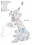
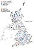
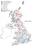
January was a month of contrasts: the UK temperature was near-average, but it was colder and wetter than average in south-east England, and milder and drier in north-west Britain. While there were some unsettled spells, blocking anticyclonic conditions supressed frontal rainfall for the latter half of the month. There were few deep depressions (although storm surge conditions prompted evacuations on the east coast on the 13th) and notable daily rainfall totals and fluvial flood alerts were rare by the standards of recent winters. The dry January has extended long-term rainfall and runoff deficiencies. January saw modest, but welcome, replenishment in many reservoirs, but at the national scale stocks remained substantially below average (for England & Wales as a whole, stocks were the lowest for January since 1997). Stocks were 30% below average or lower in some impoundments (Wimbleball and Ardingly in southern England, and Silent Valley in Northern Ireland). Rainfall across aquifer areas in the English Lowlands triggered localised increases in groundwater levels, but levels remain well below the normal range across the Chalk. In most areas, water resources are generally resilient to a single dry winter, but the observed deficiencies increase the potential for pressures later in the year. With the window for substantial aquifer and reservoir replenishment narrowing before evapotranspiration rates begin to climb, late-winter/early-spring rainfall patterns will have a significant bearing on the long-term water resources outlook. February started wet, but the latest outlooks suggest a drier end to winter and no clear signal for the spring.
The full Hydrological Summary can be found here.