The National River Flow Archive (NRFA) has released an update to the NRFA Peak Flow Dataset. The Version 15 dataset consists of the data files for use in the WINFAP software for flood estimation and updates to the accompanying metadata. The dataset includes Annual Maxima (AMAX) and Peaks Over Threshold (POT) data for 949 gauging stations of which 636 are in England, 181 are in Scotland, 94 are in Wales, and 38 are in Northern Ireland. The data from individual river flow gauging stations are categorised by their indicative suitability which relates to the hydrometric quality of flow data. A total of 558 stations are recommended for use in pooling groups (‘Suitable for Pooling’), 366 stations are ‘Suitable for QMED only’ and 25 stations are ‘Suitable for Neither’.
The Version 15 release includes the following updates:
- Addition of water year 2024/2025 data at all active peak flow stations (covering the period ending 30 September 2025)
- Network changes (addition, removal, and closure of gauging stations)
- Full period of record data and metadata reviews for a subset of stations in the dataset (79 stations)
- A comprehensive review and reconciliation of bankfull and structurefull stage metadata across the network, resulting in updates to 558 stations
- Additional network updates, including a review of POT thresholds in Northern Ireland and implementation of findings from the non-stationarity (FRS18087) project in England
- Modifications to existing time series (e.g. POT thresholds, rating curves and unrepresentative periods)
- Inclusion of provisional data during the current water year (ending 30 September 2026) for two stations in Wales, 55029 Monnow at Grosmont and 60006 Gwili at Glangwili, to speed up the availability of provisional AMAX1 data at these sites for flood estimation
Amongst the changes, 24 new stations were added to the Version 15 of the NRFA Peak Flow Dataset:
- 13007 North Esk at Logie Mill
- 27054 Hodge Beck at Cherrytree Farm
- 27074 Spen Beck at Northorpe
- 28051 Soar at Narborough
- 38012 Stevenage Brook at Bragbury Park
- 38017 Mimram at Whitwell
- 38028 Stansted Brook at Gypsy Lane
- 38029 Quin at Griggs Bridge
- 39030 Gade at Croxley Green
- 39102 Misbourne at Denham Lodge
- 40042 Medway at Allington
- 43016 Stour at Wimborne (A31)
- 43022 Moors River at Hurn Court
- 43026 Bourne at Salisbury Bourne
- 43027 Allen at All Hallows
- 49007 Camel at Bodmin Dunmere
- 52001 Axe at Wookey
- 53024 Tetbury Avon at Brokenborough
- 54088 Little Avon at Berkeley Kennels
- 54095 Severn at Buildwas
- 54098 Cam at Cambridge
- 69026 Irwell at Kearsley
- 92003 Strontian at Ariundle
- 108001 Weisdale Burn at Weisdale Mill
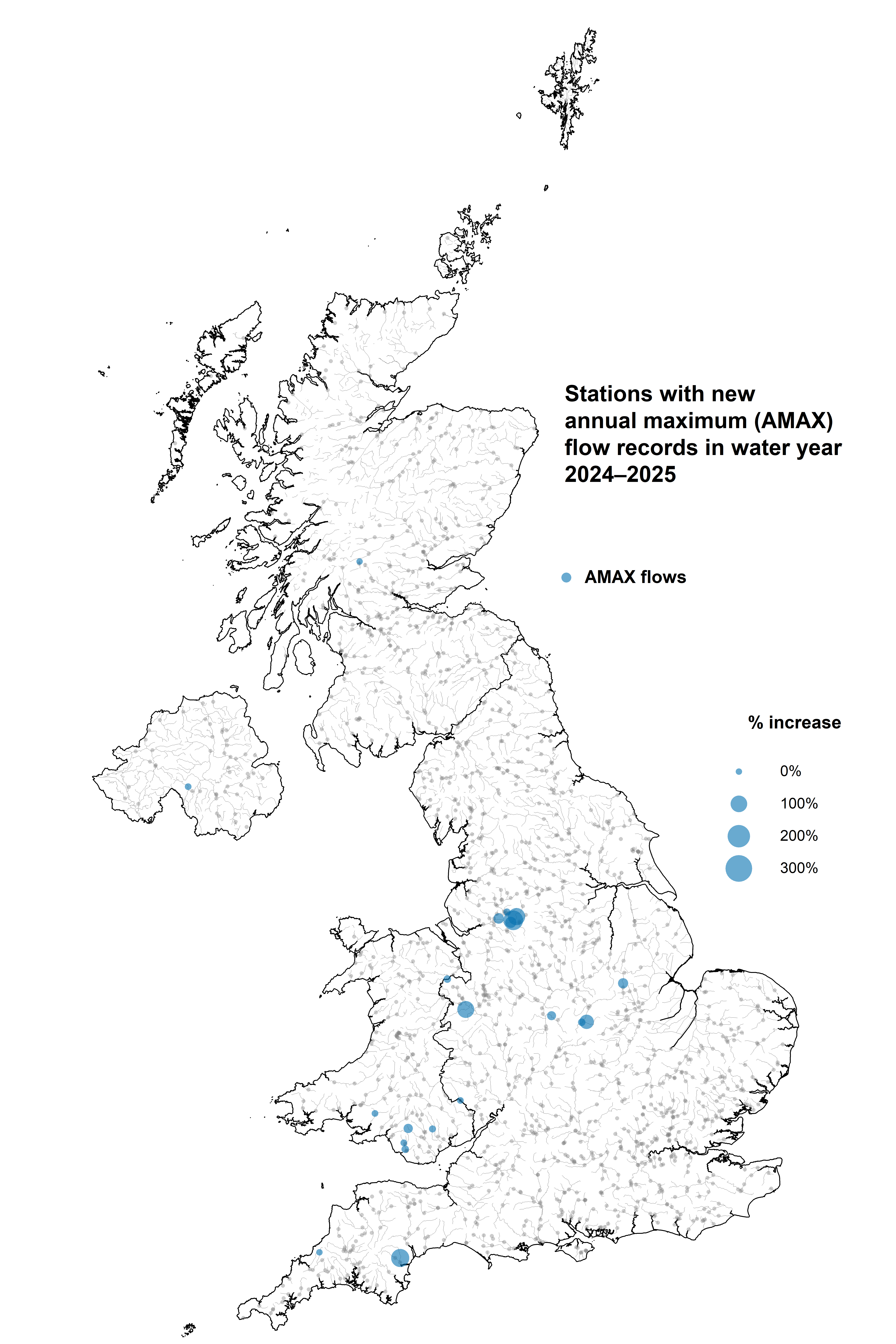
New AMAX1 records (the highest flood peak in the period of record) were established at 24 stations during water year 2024/2025 across England, Scotland, Wales and Northern Ireland.
As well as the additional water year of data, an extensive review of period of record flow and stage data, gauging and rating data and associated metadata (e.g. POT threshold, station description, rating history, missing data periods, FEH Indicative Suitability, rejected years) was undertaken for 79 stations (17 stations in Scotland, 45 stations in England, 10 in Wales and 7 stations in Northern Ireland).
During the Period of Record Review, almost 3,450 years of data were reviewed!
A list of stations that were included in this year’s period of record data review can be found in the release note of the NRFA Peak Flow Dataset.
The new release also includes updated bankfull and structurefull stage metadata across the river flow network, resulting from a comprehensive reconciliation of legacy HiFlows-UK, NRFA and Measuring Authority records. This exercise was undertaken with invaluable support from colleagues across the UK Measuring Authorities, resulting in updates to metadata holdings for 558 stations.
The NRFA Peak Flow Dataset provides flood data for 949 river flow gauging stations across the UK. The data can be used with the flood estimation methods set out in the Flood Estimation Handbook (FEH), which is the industry standard for current flood estimation in the UK. The NRFA Peak Flow Dataset has been shown to provide net economic benefits of almost £5.4 million per year in terms of costs saved by environmental consultants and regulators.
The peak flow data provided through this service originate from gauging stations operated by a range of UK hydrometric Measuring Authorities as is the case with other NRFA data. Maintenance of the NRFA Peak Flow Dataset, including the latest update, is carried out under a collaborative project between the UK Centre for Ecology & Hydrology, the Environment Agency, Natural Resources Wales, Northern Ireland’s Department for Infrastructure – Rivers Directorate, and the Scottish Environment Protection Agency. Many systems from the wider National River Flow Archive that underpin this update are supported by NC-UK [NE/Y006208/1] and NERC National Capability.
The updated NRFA Peak Flow Dataset (Version 15) was released on 27 August 2026 and reflects the NRFA data holdings as of that date. It is the twelfth version released since the NRFA took stewardship of the national Peak Flows database. Updated peak flow time series and metadata are now available to view on the NRFA website and can be found using the NRFA’s gauging station search tool.
More information about the update can be found in the Version 15 release note.